
Combining drones with ground penetrating radar transforms utility mapping, making it faster, safer, and more cost-effective while delivering highly accurate information and data that significantly improve project outcomes.
Mapping underground utility networks is an essential task for professionals in utilities, construction, and infrastructure. However, traditional mapping methods often come with high costs, slow processes, and potential safety risks. Combining drone utility mapping with ground penetrating radar (GPR) offers a faster, safer, and more precise solution. In this blog, we’ll explore how this technology can revolutionise utility mapping, saving time, reducing costs, and improving the accuracy of subsurface data.
Why Traditional Utility Mapping Methods Are Inefficient
Traditional utility mapping methods often rely on manual surveys, excavation, and outdated maps, which can result in delays, errors, and safety concerns. These methods are also expensive, involving significant labour and equipment costs. Workers may need to access hazardous areas, increasing the risk of accidents. To complicate matters, the data gathered is often inaccurate or incomplete, which can lead to costly mistakes in construction or utility maintenance.
How Drones + GPR Revolutionise Utility Mapping
The integration of drone utility mapping with GPR technology provides a far more effective approach to underground utility surveys. Here’s how these technologies work together:
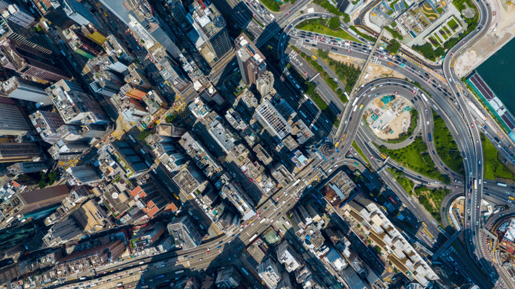
UAV Drone Surveying for Precision and Speed
Drones equipped with high-resolution cameras and LiDAR sensors make it possible to cover large areas quickly and accurately. These UAVs (unmanned aerial vehicles) capture detailed aerial data, creating precise surface maps of the land, which help to detect surface-level obstacles and terrain features.
- Fast and Efficient: Drones can survey expansive areas in a fraction of the time it would take with traditional methods.
- Cost-Effective: By reducing the need for manual labour and lowering the amount of time spent on-site, drone surveys significantly reduce project costs.
With UAV Drone Survey technology, utility professionals can collect data more efficiently, streamlining their surveying operations. utility professionals can collect data more efficiently, streamlining their surveying operations.
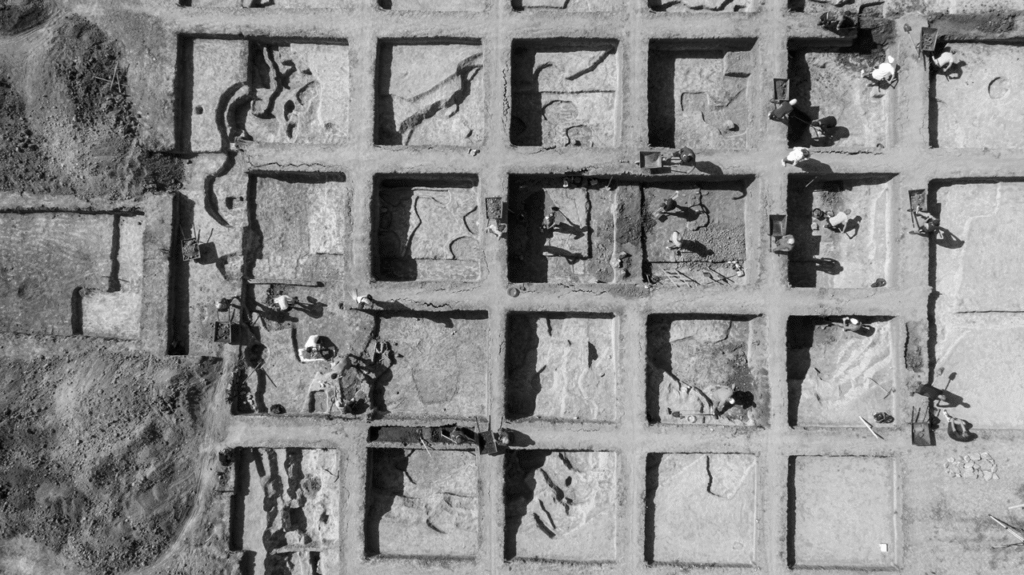
GPR for Subsurface Mapping
While drones provide valuable surface-level data, GPR is used to scan beneath the ground, providing detailed images of underground utilities. GPR sends radar pulses into the earth and captures the signals that bounce back, helping to detect pipes, cables, and other underground infrastructure.
- Accurate and Non-Disruptive: GPR allows professionals to map utilities without needing to dig, making it a non-invasive, safe, and reliable method.
- Complementary to UAVs: Drones can carry GPR equipment, providing an efficient way to perform both aerial and subsurface mapping.
This combination of UAV Mapping and GPR technology ensures accurate, high-quality data for mapping underground utilities with minimal disruption to the environment.
Key Benefits of Using Drones and GPR for Utility Mapping
Cost Savings
Drones paired with GPR technology significantly reduce the need for manual labour, excavation, and re-surveys. Reducing the time spent on-site and the number of workers required lowers costs and shortens project timelines. This makes drone utility mapping a highly cost-effective solution.
Time Efficiency
Traditional utility mapping methods often require weeks or months of work. By contrast, drones and GPR can complete the same task in a fraction of the time. UAVs can cover large areas quickly, and GPR provides immediate subsurface data, reducing the overall time needed for surveys.
Improved Accuracy
The high-resolution data captured by drones, combined with the detailed subsurface information from GPR, ensures a highly accurate map of utility networks. This enhanced accuracy helps utility companies avoid costly mistakes, such as damaging underground pipes or cables during construction.
Improved Safety
Drones improve safety by eliminating the need for workers to access potentially hazardous areas. Drones can survey hard-to-reach or dangerous zones without putting personnel at risk, significantly reducing the chance of accidents.
Applications for Utility Networks
Utility companies, construction firms, and infrastructure projects can all benefit from the combination of drones and GPR. Here’s how this technology is being used across different industries:
Water, Gas, and Electric Utilities
Utility companies rely on accurate maps of underground infrastructure to maintain and repair pipelines, cables, and other utilities. Drones and GPR allow for precise mapping of these assets, helping companies identify issues such as leaks or blockages without disrupting service.
Telecommunication Networks
Telecom companies use drones and GPR to map underground telecom cables and networks, ensuring that their infrastructure remains intact during construction projects. This helps prevent costly disruptions and improves maintenance planning.
Infrastructure Projects
Large-scale infrastructure projects require precise utility mapping to avoid costly errors during construction. The combination of drone utility mapping and GPR ensures that all underground assets are accurately mapped, reducing the risk of encountering unplanned utility lines or pipes.
Why FEDS is the Leading Provider of Drone Utility Mapping Services
At FEDS, we provide expert UAV Drone Survey services that integrate seamlessly with GIS & Remote Sensing Technology technology to deliver precise, real-time utility mapping solutions. With extensive experience in the UAE and surrounding regions, FEDS is uniquely positioned to offer drone utility mapping services that meet the needs of utility companies, construction firms, and infrastructure projects.
Our UAV Survey and Drone Survey Service are designed to ensure that utility network mapping is done accurately, efficiently, and safely.
Final Thoughts: Unlock the Benefits of Drone + GPR Utility Mapping
By combining drones with ground penetrating radar, utility mapping becomes faster, more accurate, and far safer. The integration of these technologies reduces costs, accelerates project timelines, and ensures that underground utilities are mapped with precision. This is the future of utility mapping.
Key Benefits Summary
- Cost-effective by reducing manual labour and excavation
- Time-efficient, covering large areas quickly
- Accurate, providing reliable data for better decision-making
- Safer, keeping workers out of hazardous areas
Contact Us
Ready to transform your utility mapping process? Contact us today to discover how drones and GPR can optimise your projects, improve efficiency, and enhance safety in utility network mapping.
Partner Credit: Vracity
Mapping Underground Utility Networks: Drones + Ground Penetrating Radar
Combining drones with ground penetrating radar transforms utility mapping, making…
Read
Drones for Substation Inspection: Boosting Grid Reliability in Extreme Weather
Climate scientists agree that extreme weather events are becoming more…
ReadSubscribe to our newsletter
Get the latest drone news and updates sent straight to your inbox.
Subscribe