
Hands-on Workshop on senseFly’s Newest Survey & Mapping Drone
In our previous article about the eBee Geo, we spoke about the backpack that it comes in; and how you could walk…
In our previous article about the eBee Geo, we spoke about the backpack that it comes in; and how you could walk…

BIM revolutionised the construction industry by changing the way buildings were designed and constructed. Since then, BIM is now widely…

The age of guesswork in farming is over. With agriculture drone mapping and advanced drone technology, we are witnessing a major shift in…

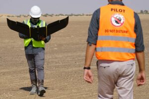
Early last month senseFly came out with two new products to add to their eBee line, the eBee Geo and eBee Ag.…

Meet the present’s needs without compromising future generations’ ability to meet their own; This is the principle at the core…

Precise & Rapid – these are some of the fundamental requirements of Geographic Systems. SfM (Structure from Motion) software is…

Commercial drone companies, known for their versatile payloads, cater to various sectors from construction site monitoring to precision agriculture. Hiring…
The most common challenges in construction revolve around saving time and money while simultaneously improving the safety of employees. Keeping…

Corona Loss – the rate at which power is leaked out by corona discharge from high voltage OHTL (Over Head Transmission…

Energy consumption per capita is increasing rapidly, so much so that according to International Energy Statistics, global electricity consumption is rising…